| Version 16 (modified by jazz, 17 years ago) (diff) |
|---|
Step by Step building Your Own Google Map Application
申請 Gooogle Map API Key
- http://code.google.com/apis/maps/signup.html
- 勾選同意使用規範,輸入網址,點選『Generate API Key』
- 產生 API Key 完畢就會得到第一個 HTML 範例
- 把 HTML 範例貼到 goglemap.html 檔案放置在 www 目錄(Ex. /var/www)中,就可以看到第一個成果囉 :)
解析網站原始碼
- 參考 http://deepsea.biodiv.tw/locamapd.asp (PART 1)
  function load() {
    PassValue();                                             // 解析 URL 中帶的參數
    if (GBrowserIsCompatible()) {
      var map = new GMap2(document.getElementById("map"));  // 取得 DOM 中,名稱為 map 的元件
      map.addControl(new GLargeMapControl());               // 加入左上角比例尺規控制列
      map.addControl(new GMapTypeControl());                // 加入右上角"地圖","衛星","混合地圖"按鈕
      map.setCenter(new GLatLng(23.8,121), 7);              // 設定預設經緯度北緯 23.8, 東經 121, 預設比例尺 100 公里(7)
      map.setMapType(G_SATELLITE_MAP);                      // 設定預設底圖為"衛星"
    }
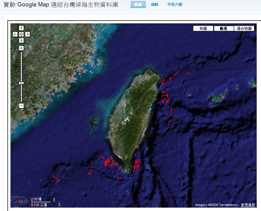
- 我們把 function load() 裡面的程式加進 HTML 範例中, 就可以得到第二個成果囉 :)
這裡我額外加了 GScaleControl 元件, 來得知目前比例尺是多大. 這樣就可以知道數值 7 是對應比例尺 100 公里, 數值 8 是對應 50 公里.map.addControl(new GScaleControl()); // 加入左下角比例尺狀態列
- 繼續解析 http://deepsea.biodiv.tw/locamapd.asp (PART 2)
  var request = GXmlHttp.create();                          // 產生一個非同步的 AJAX XMLHttp 物件 (Jazz: 好簡單的一行 AJAX 啊!!)
  if (queryPair[0]=='R1') {                                 // 這段是用在對應"物種統計"與"科別統計"的 URL 解析上
    var GetDataXml="getdeepstaxml.asp?" + queryPair[0] + "=" + valuePair[0] + "&" + queryPair[1] + "=" + valuePair[1];
  }
  else {
    var GetDataXml="getdeepstaxml.asp";                     // 預設因為 queryPair[0] 是空的, 所以資料來源來自 getdeepstaxml.asp
  }
  request.open("GET",GetDataXml, true);                     // 用 XMLHttp 物件去開啟 http://deepsea.biodiv.tw/getdeepstaxml.asp
- 我們首先來看 http://deepsea.biodiv.tw/getdeepstaxml.asp 所回傳的 XML 資料
這是一筆 XML 紀錄
<marker lat1="24.8078" lng1="122.04" lat2="24.86533" lng2="122.04067" id="CD121" depth="471-531 m"/>
依格式看來 (lat1, lng1) 是起點, (lat2, lng2) 是終點, id 是測站代號, depth 是魚網打撈的水深範圍
- 繼續解析 http://deepsea.biodiv.tw/locamapd.asp (PART 3)
  request.onreadystatechange = function() {                // 定義 XMLHttp 有狀態改變的事件處理函數 callback function
    if (request.readyState == 4) {                         // XMLHttp 的狀態是 Ready (4) 繼續處理 Server 傳回的 XML 資料
      var xmlDoc = request.responseXML;                    // xmlDoc = 回傳的 XML 資料
      var markers = xmlDoc.documentElement.getElementsByTagName("marker"); // 取出名稱為 marker 的 xml 元件, 結果是陣列
      for (var i = 0; i < markers.length; i++) {
        var points2 = [];                                  // 宣告一個空的陣列 point2 來存起始與結束座標點
        // 把 lat1 跟 lng1 塞進起始座標點 GLatLng 物件
        points2.push(new GLatLng(parseFloat(markers[i].getAttribute("lat1")),parseFloat(markers[i].getAttribute("lng1"))))
        // 把 lat2 跟 lng2 塞進起始座標點 GLatLng 物件
        points2.push(new GLatLng(parseFloat(markers[i].getAttribute("lat2")),parseFloat(markers[i].getAttribute("lng2"))))
        // 用 point2 產生 GPolyline 物件,畫從 point2[2] 到 point2[1] 的線條
        // - 參考 http://code.google.com/apis/maps/documentation/reference.html#GPolyline
        // - GPolyline(座標點, 顏色, 線條粗細(pixel), 透明度(0: 反鋸齒, 1: 半透明))
        // 然後用 addOverlay 函數把線條疊到地圖上
        map.addOverlay(new GPolyline(points2,'#FF0000',2,1));
        // 計算起始與結束的中心位置座標點
        var lat=(parseFloat(markers[i].getAttribute("lat1"))+parseFloat(markers[i].getAttribute("lat2")))/2
        var lng=(parseFloat(markers[i].getAttribute("lng1"))+parseFloat(markers[i].getAttribute("lng2")))/2
        // 產生中點 GLatLng 座標物件
        var point = new GLatLng(lat,lng);
        // 取得 XML 資料中的測站名稱(id)與打撈深度(depth)
        var id=markers[i].getAttribute("id")
        var depth=markers[i].getAttribute("depth")
        // 呼叫自訂的 createMarkerWithLnk() 來產生一個具有連結的 Marker 物件
        // createMarkerWithLnk(中點座標位置,測站代號,自訂圖示,測站打撈深度)
        var marker = createMarkerWithLnk(point,id,icon,depth);
        // 把 Marker 物件貼上地圖
        map.addOverlay(marker);
      }
    }
  }
  request.send(null);                                      // 送出 XMLHttp 物件的要求
}
- 繼續解析 http://deepsea.biodiv.tw/locamapd.asp (PART 4) - 自訂的 createMarkerWithLnk() 函數
  // 自訂的 createMarkerWithLnk() 來產生一個具有連結的 Marker 物件
  // createMarkerWithLnk(中點座標位置,測站代號,自訂圖示,測站打撈深度)
  function createMarkerWithLnk(point,id,icon,depth) {
    var urlstr= id + " Depth:" + depth;                   // 提示字串="測站代號 Depth:打撈深度"
    var url="species.asp?id=" + id;                       // 連結網址=http://deepsea.biodiv.tw/species.asp?id=測站代號
    // 產生一個 GMarker 物件
    // - 參考1 http://code.google.com/apis/maps/documentation/reference.html#GMarker
    // - 參考2 http://code.google.com/apis/maps/documentation/reference.html#GMarkerOptions
    // - GMarker(座標位置, GMarkerOptions)
    // - GMarkerOptions={icon:自訂圖示 GIcon 物件, clickable: 可點選(true), title: 顯示提示字串}
    var marker = new GMarker(point,{icon:icon, clickable:true, title:urlstr});
    // 用 GEvent.addListener 設定 GMarker 被點選時的事件處理函數
    // 這裡定義的是遇到 click 事件時把 URL 導向到 url 變數設定之連結網址
    GEvent.addListener(marker, "click", function() {location.href=url});
    // 回傳 GMarker 物件
    return marker;
  }
實驗跨站取得 XML 資料
- 首先把 GetDataXml 設定成 "http://deepsea.biodiv.tw/getdeepstaxml.asp", 把 HTML 範例改寫成
<!DOCTYPE html PUBLIC "-//W3C//DTD XHTML 1.0 Strict//EN" "http://www.w3.org/TR/xhtml1/DTD/xhtml1-strict.dtd"> <html xmlns="http://www.w3.org/1999/xhtml"> <head> <meta http-equiv="content-type" content="text/html; charset=utf-8"/> <title>Google Maps JavaScript API Example</title> <script src="http://maps.google.com/maps?file=api&v=2&key=ABQIAAAAREq2HXjZzIdAyVORbKBYMhTGA1AmqT3f4EHIxhq9FLpYC-sN5RSNOiRjrKXraxSIlkXZKb9VzUKDWQ" type="text/javascript"></script> <script type="text/javascript"> //<![CDATA[ function load() { if (GBrowserIsCompatible()) { var map = new GMap2(document.getElementById("map")); // 取得 DOM 中,名稱為 map 的元件 map.addControl(new GLargeMapControl()); // 加入左上角比例尺規控制列 map.addControl(new GScaleControl()); // 加入左下角比例尺狀態列 map.addControl(new GMapTypeControl()); // 加入右上角"地圖","衛星","混合地圖"按鈕 map.setCenter(new GLatLng(23.8,121), 7); // 設定預設經緯度北緯 23.8, 東經 121, 預設比例尺 100 公里(7) map.setMapType(G_SATELLITE_MAP); // 設定預設底圖為"衛星" } var request = GXmlHttp.create(); // 產生一個非同步的 AJAX XMLHttp 物件 var GetDataXml="http://deepsea.biodiv.tw/getdeepstaxml.asp"; request.open("GET",GetDataXml, true); // 用 XMLHttp 物件去開啟 http://deepsea.biodiv.tw/getdeepstaxml.asp request.onreadystatechange = function() { // 定義 XMLHttp 有狀態改變的事件處理函數 callback function if (request.readyState == 4) { // XMLHttp 的狀態是 Ready (4) 繼續處理 Server 傳回的 XML 資料 var xmlDoc = request.responseXML; // xmlDoc = 回傳的 XML 資料 var markers = xmlDoc.documentElement.getElementsByTagName("marker"); // 取出名稱為 marker 的 xml 元件, 結果是陣列 for (var i = 0; i < markers.length; i++) { var points2 = []; // 宣告一個空的陣列 point2 來存起始與結束座標點 // 把 lat1 跟 lng1 塞進起始座標點 GLatLng 物件 points2.push(new GLatLng(parseFloat(markers[i].getAttribute("lat1")),parseFloat(markers[i].getAttribute("lng1")))); // 把 lat2 跟 lng2 塞進起始座標點 GLatLng 物件 points2.push(new GLatLng(parseFloat(markers[i].getAttribute("lat2")),parseFloat(markers[i].getAttribute("lng2")))); // 用 point2 產生 GPolyline 物件,畫從 point2[2] 到 point2[1] 的線條 // - 參考 http://code.google.com/apis/maps/documentation/reference.html#GPolyline // - GPolyline(座標點, 顏色, 線條粗細(pixel), 透明度(0: 反鋸齒, 1: 半透明)) // 然後用 addOverlay 函數把線條疊到地圖上 map.addOverlay(new GPolyline(points2,'#FF0000',2,1)); } } } request.send(null); // 送出 XMLHttp 物件的要求 } //]]> </script> </head> <body onload="load()" onunload="GUnload()"> <div id="map" style="width: 800px; height: 600px"></div> </body> </html>
- 結果發現並不會正常畫出紅線, 因此用 wget 先把 XML 抓下來
jazz@trac:/var/www$ wget http://deepsea.biodiv.tw/getdeepstaxml.asp
jazz@trac:/var/www$ mv getdeepstaxml.asp getdeepstaxml.xml
- 再把 XMLHttp 物件要去 GET 的 URL 改為 getdeepstaxml.xml , 就可以正常看到紅線了~
請看第三個成果-
googlemap2.html
20 var GetDataXml=" http://deepsea.biodiv.tw/getdeepstaxml.asp";20 var GetDataXml="getdeepstaxml.xml";
-
- [猜測] 或許為了安全性, Google Map API 所產生的 XMLHttp 物件不允許連結外部 URL
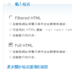
用 iframe 將 Google Map 加入 Drupal 頁面
Attachments (6)
- GoogleMapKey.jpg (23.6 KB) - added by jazz 17 years ago.
- GoogleMapSample.jpg (93.6 KB) - added by jazz 17 years ago.
- biodiv_xml.jpg (143.7 KB) - added by jazz 17 years ago.
- Drupal_iframe_1.jpg (40.0 KB) - added by jazz 17 years ago.
- Drupal_iframe_2.jpg (26.6 KB) - added by jazz 17 years ago.
- Drupal_iframe_3.jpg (312.0 KB) - added by jazz 17 years ago.
Download all attachments as: .zip


